Basic Rules & Regulations
- All boaters should have a working knowledge of the basic maritime rules and regulations.
- Maintain all required equipment in ship-shape condition and equip boat with a first aid kit.
- Do not overpower or overload your boat
- Always inform another person of your boating intentions – where you are going and when you intend to return.
- Stay ashore in threatening weather.
- Obey all fire safety rules when filling with gasoline. Gasoline vapors are explosive, and being heavier than air will settle in the lower parts of a boat.
- The law requires Coast Guard approved life jackets for all passengers. Be water wise and wear yours while afloat.
- Avoid navigating close to pile or rock structures. It is particularly hazardous to navigate immediately upstream or off end of dikes. Some dike ends and revetments are submerged and not visible.
- Yield the right-ofway to all large commercial tows.
- Avoid navigating in the vicinity of construction work or dredging operations.
- Avoid bridge piers, drift and snags when operating out of the buoyed channel. Very shallow water may reach well into the river, particularly in bends across revetments.
- Observe all port regulations. Navigate in the vicinity of port areas with caution. Always stay alert for other boats, fishermen, and partly submerged logs. Be courteous, watch your wake.
- Travel in buoyed channel. Don’t anchor in a buoyed channel.
- If your boat capsizes or swamps, hang on to it. Do not try to swim to shore. Swim the capsized boat toward safety.
- Land your craft headed upstream when operating in the current of the river. Downstream landings are dangerous in swift current.
Recreation Areas

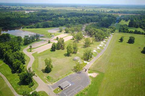
Alexandria Levee Park
- 3 lane boat launch
- 150 foot floating wharf
- Cooking grills
- 1 picnic shelter
- 22 covered picnic tables
- Playground
- Scenic overlook
- 2 comfort stations
- Access road
- Parking spaces
- Hiking trails
- Outdoor amphitheater
- River plaza
- Stone embankment
Directions:
- Boat launch and picnic shelters enter at the Farmers Market on North Third St.
- Amphitheater and scenic overlooks – enter from Winn St. at Main St. There is also a pedestrian entry from Main Street at Murray St. Follow signs.

Ben Routh
- 4 lane boat launch
- 1 boat dock
- Cooking grills
- 25 picnic tables
- Trash receptacles
- 2 Playgrounds
- 2 Playfields
- 2 comfort stations
- Access roads
- 126 Parking spaces
- Scenic overlook
- Hiking trails
Directions
- From Marksville: take LA Hwy 107 North 7.1 miles to LA Hwy 1196. Turn right on LA Hwy 1196, go 2 miles to Ben Routh Road. On the right is the entry to the recreation area.
- From Alexandria: depart LA Hwy 167 – Cottingham Expressway on to LA Hwy 107. Go 20 miles to LA Hwy 1196. Turn left on LA Hwy 1196 and go 1.2 miles to Ben Routh Road. On the right is the entry to the recreation area.

Bishop Point
- 2 lane boat launch
- 9 picnic tables w/grills.
- Picnic pavilion
Directions
- 12 Miles South of Shreveport

Boyce
- 2 lane boat launch
- Bank fishing
- Grills
- Picnic shelter
- 12 picnic tables
- Access road
- 60 parking spaces
- Walking trails
- Parking lot
Directions:
- From US 71 & 165 in Alexandria: take I49 North for 12.5 miles, exit I-49 at Exit 98 (Louisiana Highway 1). Continue north to Boyce, LA for 1.5 miles, then turn right on Ryan Street. Continue on Ryan Street for four (4) blocks, which leads to the entrance of Boyce Recreation Area.

Brouillette
- 1 lane boat launch
- Trash receptacles
- Roads
- 23 parking spaces
Directions:
Take Louisiana Highway 452 north from Marksville, a distance of 6.0 miles to Boat Ramp Road, on left. Cross over levee into recreation area.

Colfax
- 2 lane boat launch
- 2 picnic shelters
- Playground equipment
- Security gate
- Comfort stations
- Wash house
- Boat ramp
- 62 parking spaces
- Floating wharf
- RV dump station
- Picnic units w/grills
- 25 RV sites
Coushatta
- 2 lane boat launch
- Boat dock
- Picnic shelter
- Picnic tables
- Cooking grills
- Comfort station
- 106 parking spaces
Directions:
From the intersection of US Highways 84 and 371 in Coushatta, turn West on Carroll Street. Follow Carroll Street to the intersection of Abney Street. Turn right on Abney Street and follow Abney to entrance of the park.

Fort Buhlow
- 3 lane boat launch
- Boat dock
- 3 Picnic shelters
- Picnic tables
- Hiking trails
- Cross country course
- Playground
- Playfield
- Access road
- Parking spaces
- 3 comfort stations
- Roads
- Water Fountain
- Bleachers
- Lighted ballfield with scoreboard
- Concession stand and press box
- Parking lots
- Grills
- Trash receptacles
- CONTACT (318) 448-1465 FOR ALL RESERVATIONS
Directions:
From Alexandria, cross the CurtisColeman Bridge (formerly the O.K. Allen Bridge) US 71 & 165 and proceed north for 1.0 mile, turn left on road immediately north of state weigh station identified by Highway sign as Ft. Buhlow Recreation Area. Stay on said road a distance of 1.0 mile, turn right onto entry of recreation area.
Grand Ecore
- Picnic tables w/cooking grills
- Comfort station
- Picnic shelters
- Asphalt surfaced access road
- Parking lot for 100 vehicles with trailers
- 2 lane concrete boat launch
Directions:
Leaving Natchitoches, travel eastbound on LA Hwy 6. Just prior to the Red River Grand Ecore Bridge, turn left at the Corps of Engineers Welcome Center on Tauzin Island Road.

Montgomery
- 1 lane boat launch
- Fire ring
- Access road
- 10 parking spaces
Directions:
Take US Highway 71 to Montgomery and turn West at the caution light. Proceed over the railroad tracks and through downtown to the intersection of Old Jefferson Highway, then turn right. Proceed to Access Road to boat ramp on the left.
Natchitoches
- 2 lane concrete boat ramp
- Bank fishing areas
- Picnic facilities w/ grills
- Boat dock
- Asphalt parking
Directions:
Follow signs from LA Highway 494.

North Caddo Bossier
- 2 lane boat launch
- 3 picnic tables with grills
- Boat dock
- 25 parking spaces
Directions:
Louisiana Highway 2.

Lock & Dam #1 (Lindy C. Boggs)
- Bank fishing
- Grills
- Covered picnic tables
- Trash receptacles
- Playground
- Comfort station w/overlook
- Roads and parking spaces
Directions:
Take Louisiana Highway 452 (Brouillette Highway) north out of Marksville, about 11 miles. Look for Corps of Engineers sign on the left side of the road at the foot of the levee. Ramp over levee to lock and dam recreation area.

Lock & Dam #2 (John H. Overton)
- Bank fishing
- Trash receptacles
- Comfort station with overlook
- Roads and parking spaces
Directions – Left Bank:
From Pineville, take Louisiana Highway 107 south for 5.7 miles to Louisiana Highway 454. Turn right on Louisiana Highway 454, go 3.4 miles to Corps of Engineers sign on the right side of the road. Take road for 3.0 miles to J. H. Overton Lock and Dam No. 2 recreation area
Directions – Right Bank:
From Alexandria, take Highway 1 South, go 5.8 miles to Highway 457 and go 3.5 miles to the Corps of Engineers sign. Take a left and go 1 mile to Lock and Dam #2 recreation area.

Lock & Dam #3
Directions:
From Colfax Downtown, follow Main Street approximately 2 miles.

Lock & Dam #4 (Russell B. Long)
Directions:
From Coushatta, follow LA 480 South approximately 10 miles.

Lock & Dam #5 (Joe D. Waggonner, Jr.)
Directions:
From Shreveport, follow LA Hwy 1 South approximately 15 miles.
Old River Lock and Dam
Directions:
From Marksville: Travel south 25.5 miles on LA Hwy 107/LA Hwy 1 towards Lettsworth. Turn left on LA Hwy 15/LA Hwy 970 and travel 5 miles. Turn right and continue 0.4 miles and follow signs to Old River Lock.
Poland
- 2 lane concrete boat launch
- Asphalt access road
- Asphalt parking lot to accommodate 50 vehicles
- 3 picnic units
Directions:
- Located on the old river channel on the right descending bank of the Red River near Lock & Dam No. 2.
- From Alexandria: At the intersection of Hwy 28 and Hwy 1, the Pineville Expressway, go south on LA 1 approximately 9 miles to Hwy 457. Turn left on Hwy 457 and go 3.5 miles to the lock and dam closure road. Then, turn left on the closure road and travel approximately ¾ mile to the park entrance.
- From Marksville: Travel north on LA 1 approximately 17 miles to the intersection of Hwy 1 and Hwy 1198. Turn right on LA 1198 and go 1 mile to LA 457. Turn left on LA 457 and go ½ mile to the lock and dam closure road. Turn right on the closure road and go approximately ¾ mile to the park entrance.
Red Bayou
- 2 lane boat launch
- Asphalt parking lot
- 3 picnic tables with grills
Directions:
- Easy access to one of the more popular areas for sportsmen on the river.
- Follow signs from Cloutierville on LA Highway 491.
Red Oak Lake
- 50 asphalt parking spots
- Asphalt road
- 2 lane concrete boat launch w/access to Red River
- Asphalt parking lot
- 2 picnic tables with grills on concrete pads
- Seawall bank
- Fishing area
Directions:
From Coushatta, proceed south on LA Hwy 480 approximately 6 miles. Turn right at the Lock and Dam #4 access road crossing the KCS railroad track, then immediately turn right onto the asphalt road 1 mile to the facility.

Shreveport Riverview
- Rose plaza
- 400 foot floating dock
- Hard surface river walk
- Cross Bayou Historic Park
- Scenic overlooks
- Interactive fountains
- Grass amphitheather
Directions:
From I49 North, exit onto I-20 East. Take the Spring Street exit to downtown. Right on Crockett Street and drive straight into the park.

St. Maurice
- 2 lane boat launch
- Access road
- 80foot boat dock
- Picnic shelter
- Picnic tables
- Cooking grills
- Fire rings
- 25 parking spaces
Directions:
Take US Highway 71 to St. Maurice, then turn West, onto LA Highway 477. Follow LA 477 across railroad then turn right and follow access road to the site.
Stoner Avenue
- (2) two-lane boat launches
- 2 boat docks
- 10 picnic tables w/grills
- Hiking trails
- 104 parking spaces
- Floating restaurant
- Comfort station
Directions:
Exit onto I20 East; from I-20 East, exit onto Market Street South, merge into left lane, merge onto Youree Drive (Highway 1 South), go south on Youree Drive to intersection of East Stoner Avenue, turn left on East Stoner to site at the end of the road.
Teague Parkway
- 7 mile walking trail
- 2 lane boat launches
- 2 boat docks
- Scenic overlooks
- 7 picnic tables w/grills
- 4 picnic shelters
- 105 parking spaces
- Comfort stations
Directions:
From I49 North: Exit onto I-20 East, from I-20 East, cross Red River. Exit onto Highway 71 South, go south on Highway 71 to intersection of Airline Drive and McDade Drive, turn right onto McDade Drive to intersection of Teague Parkway; turn left on Teague Parkway and proceed south until you cross under the Barksdale bridge, then turn right into the park.
Visit our RV parks
(318) 627-2640
(318) 238-7446